The Landslide Event
In late July 2022, a series of convective storms in Eastern Kentucky resulted in up to 400 mm of rainfall over a six-day period, with a maximum 24-hour precipitation accumulation exceeding 250 mm. At times, it was raining in excess of 100 mm per hour. These accumulations for the region have a 1 in 500-year to less than a 1 in 1,000-year chance of occurring (National Oceanic and Atmospheric Administration, n.d.). The storm triggered thousands of landslides across an area of over 2,000 km2, caused record-breaking flooding, property damage, numerous road closures and forty five fatalities—mostly due to flooding.
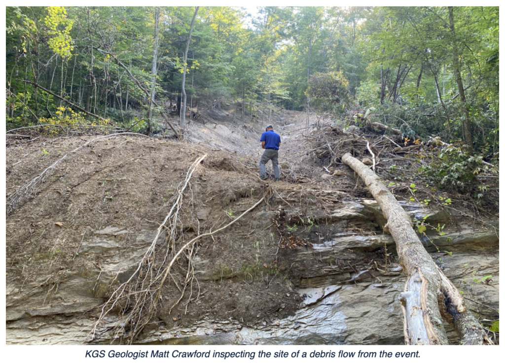
Initial field and remote-sensing based reconnaissance mapping by the Kentucky Geological Survey (KGS) identified more than 1,000 landslides believed to be from the event (Crawford et al., 2023). Most of the rapidly identified landslides were identified near roads, homes, or other built-up areas.
Using Pre- and Post-storm Lidar to find Landslides
Kentucky had collected lidar elevation data over the entire area through a combination of acquisitions in 2012 and 2017. Following the storms, lidar data was again collected in early 2023. In 2024, Cambio Earth Systems partnered with the KGS and produced post vs. pre-storm lidar change detection results for approximately 1,800 km2 of the hardest hit region. The data were provided to KGS and are actively being used to advance research in identification and characterization of landslides from lidar change detection data and to support landslide hazard risk reduction by the KGS.
Lidar change detection was processed and delivered through Cambio for detailed visualization and interaction in less than 4 weeks. This was accomplished on powerful servers sitting in our Vancouver Headquarters and a highly parallelized and optimized GPU-driven workflow built on open-source algorithms (Lato and Ferrier, 2022).
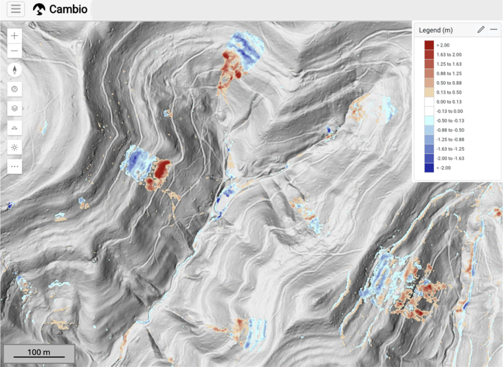
Lidar change detection permits the rapid identification of landslides that were active in the change detection period by identifying areas of erosion, subsidence, cracking, bulging, and deposition relative to stable ground. Most of the landslides in Eastern Kentucky are rapid and shallow landslides originating in colluvial soils. These landslides are typically triggered by rapid rainfall which infiltrates the soil and increases soil pore pressures, destabilizing slopes. Many of the landslides initiate in areas of anthropogenic modification like road construction or historical mining areas.
Digital mapping is currently underway and will likely identify thousands of previously unmapped landslides. It’s impossible to know exactly when (between 2012 or 2017 and 2023) these landslides triggered, but it is likely that the 1 in 1,000-year rainfall event contributed substantially to the observed ground movement.
Toggling between 2017, 2023, and lidar change detection results illustrates numerous landslides that were active in the 2017 vs 2023 period. Changes that are greater than +/- 13 cm in magnitude are shown.
References
Crawford, M.M., Zhenming, W., Carpenter, N.S., Schmidt, J., Koch H., Dortch, J., (2023) Reconnaissance of Landslides and Debris Flows Associated with the July 2022 Flooding in Eastern Kentucky: Kentucky Geological Survey, ser. 13, Report of Investigations 13, 14p. DOI: https://doi.org/10/13023/kgs.ri56.13.
Lato, M., Ferrier, A., 2022. Systems and Methods for Evaluating Changes in Terrain Topography Over Time. US 11,288,826 B1. U.S. Patent and Trademark Office.
National Oceanic and Atmospheric Administration. (n.d.). NOAA Atlas 14: Precipitation-frequency atlas of the United States, Kentucky. National Weather Service. Retrieved May 9, 2024, from https://hdsc.nws.noaa.gov/pfds/pfds_map_cont.html?bkmrk=ky